


When Captain James Cook rounded Sandy Cape in 1770 and found it now Fraser Island, he initially concluded it was part of the mainland.
Cook named the area "Hervey Bay" after Augustus Hervey, then Britain's first Lord of the Admiralty. In 1802 Matthew Flinders landed at Sandy Cape and drew detailed maps of the bay.
Indigenous Australians have inhabited the area for generations, but in 1850 acquired vast tracts of land for cattle breeding and Burrum Heads Between Booral. Pine trees grow along the foreshore attracted timber cutters in 1863 and in the mid-1860s the first five white settlers took over the seaside lease extends from Point Vernon to Urangan. Each of ground leases Developed in small townships, with sea lots being bought up by wealthy business men from Maryborough and Gympie.
Martin Boyle, Recognized as the first white settler in the bay, took the country by Pialba, which quickly became a small but thriving seaside resort. Although Torquay, named after the seaside resort in Devon Inglés and Scarborough (now Scarness) also grew rapidly, the entire area was then known as Pialba.
Coal mining began at Howard in 1863 and limestone, bismuth, magnetite and mineral sands mined also was. In 1883 two sugar factories opened in Hervey Bay and the population in Pialba swelled to 85
A railway line from Maryborough to Pialba was built in 1896, visitors and tourists essential Boosting the bay. The construction of Urangan Pier in 1913 and the extension of the railway to serve the pier, facilitated the export of sugar, coal and coffee to England.
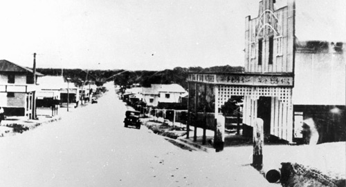
Urangan Developed as a solution for fishermen during this period, while Torquay and Scarness developed as tourist areas. Was a commercial hub Pialba and Point Vernon emerged as the primary residential area with commanding views Esplanade home sites from Pialba to Urangan Pier.
By the 1920s Hervey Bay local industries included sugar cane, citrus and pineapple plantations, livestock and fisheries. The increasing popularity of the bay as a holiday destination was yet at this point Recognised in time.
A 1964 study shows land-use residential and commercial hugging the beach from Gataker Bay at Point Vernon to Urangan the place where a boat harbor was built in 1960. Over the years this evolved into the current impressive Urangan Boat Harbour.
